
Benchmark in Surveying | TBM in Surveying | GTS Benchmark| Permanent Benchmark | Arbitrary Benchmark
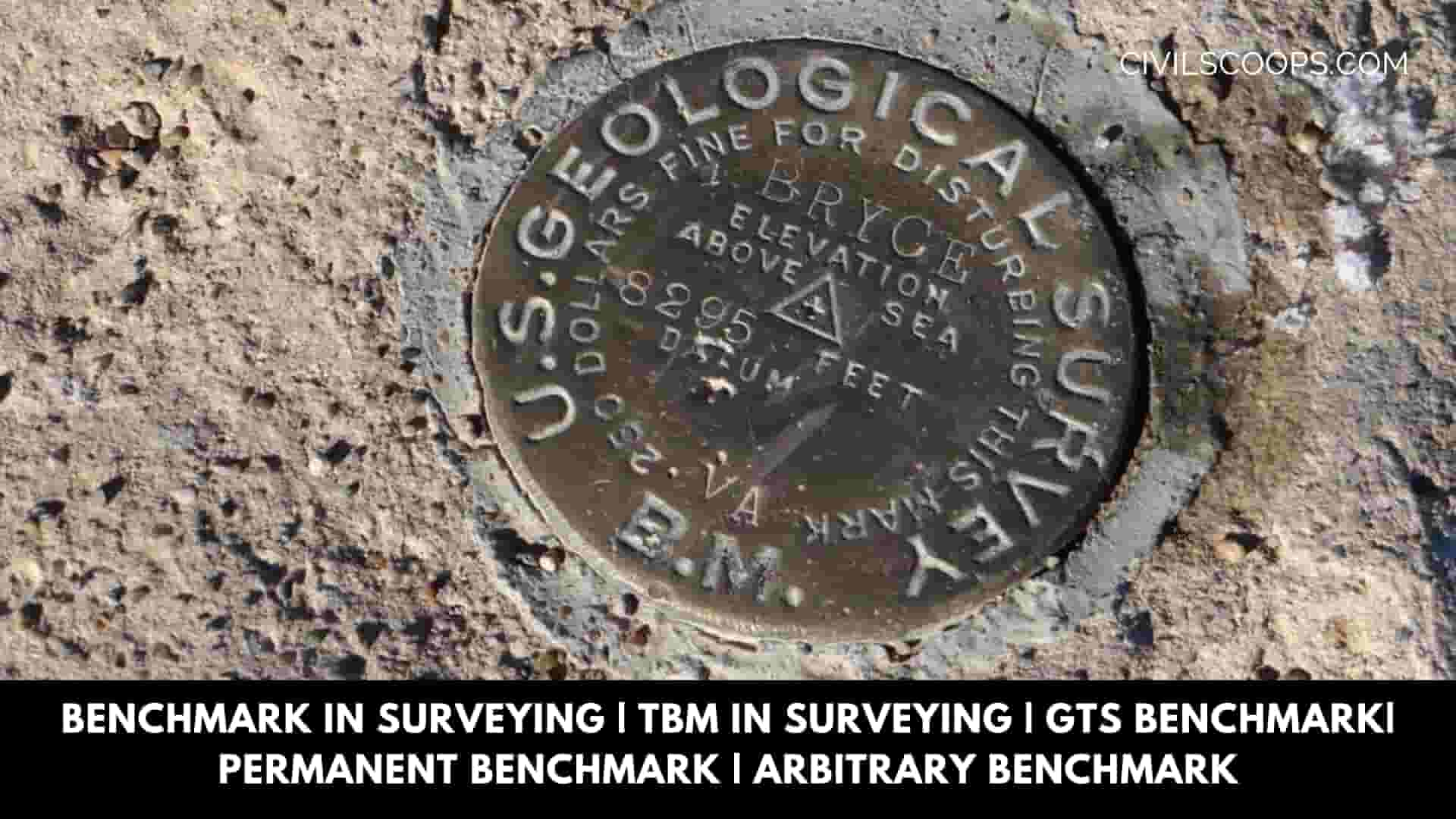
Table of Contents
What Is a Benchmark in Surveying?
Benchmark is a permanent and temporary reference point in surveying. The term is usually applied to any item used to mark a point as an elevation reference.
Type of Benchmark in Surveying
It is a relatively permanent point of reference whose elevation for some assumed datum is known. It is a starting and ending point in levelling. The following four types of bench-marks are commonly used
- GTS Benchmark in Surveying
- Permanent Benchmark in Surveying
- Arbitrary Benchmark in Surveying
- TBM in Surveying (Temporary Bench Mark)
GTS Benchmark in Surveying
A GTS Benchmark full name Great Trigonometrical Survey. GTS is a permanently fixed reference survey station, having known elevation related to respect related (MSL = Mean Sea Level). All these are established all over India by a survey of India’s departments with greater precision.
A benchmark value is quite essential in any survey area, especially for the reduction of sea level concerning mean sea level or CD (CD = Chart Datum).
While carrying out a bathymetric survey of a survey area, the datum referenced values so obtained are utilized to compute the final depth contours of this survey area for CD.
Thus, a benchmark, having known elevation, is quite essential in the survey area; without that, the preparation of a bathymetric chart is impossible.
In some places, GTS benchmarks are available within a kilometer distance and can be easily moved to the survey area by fly leveling using an automatic Level instrument along with a graduated leveling staff.
However, in the majority of the cases, GTS benchmarks might be at a much away distance in the area to be surveyed. In such cases, the most common traditional way of transferring the benchmark value using an automatic level instrument is a difficult job; consuming an enormous amount of time and labor.
To eliminate this process, a method is suggested in this technical report to move the GTS benchmark from any distance to the survey area. The latest Digital Total Station (ETS) is a tool that may be used for this purpose.
The main advantage of applying this method is a considerable amount of time could be saved while maintaining the required accuracy.
The long-form of GTS benchmark is the great Trigonometric Survey benchmark. They’re established by national agencies like a survey of India. They’re established with the highest accuracy at several locations all around the country, depending on the mean sea level.
The survey of India has used the mean sea level of Karachi (Pakistan) as a datum. All these benchmarks are indicated on a brass plate fixed to a concrete pedestal with a well-protected wall.
The U.K. Ordnance Survey and the U.S. Geological Survey have established similar, standard benchmarks in their countries. These benchmarks are used as reference or starting points for all important surveying work.
Also Read: What Is RQD | Advantages of Rock Quality Designation | Limitations of Rock Quality Designation (RQD)
As Per the Below list of agencies for different countries.
India = Survey of India
United Kingdom = Ordnance Survey
Pakistan = Survey of Pakistan
New Zealand = Land Information New Zealand
Canada = Natural Resources Canada
Japan = Geographical Survey institute
United States = The United States Geological Survey
France = Institut Géographique National
The Republic of Ireland = Ordnance Survey Ireland
Italy = Istituto Geografico Militare
South Africa = Department of Rural Development and Land Reform
Spain = Instituto Geográfico Nacional (IGN)
GTS Benchmark in Us
GTS Benchmark in India
GTS Benchmark in United Kingdom
GTS Benchmark in Pakistan
Permanent Benchmark in Surveying
Permanent benchmarks are fixed reference points established by government agencies like the erstwhile Public Works Departments in certain states, starting from the standard benchmarks such as GTS.
Conspicuous points onto culverts. Bridges and buildings are normally chosen. The exact position of the benchmark might be marked with a small rectangle or arrow, as shown in Fig. No. A bronze tablet might also be utilized.
A permanent Benchmark setup by state Government agencies like the Public Work Department (PWD) fixes such a benchmark.
Arbitrary Benchmark in Surveying
Arbitrary Benchmarks In most engineering projects, the difference in elevation is much more important compared to a reduced level when it comes to mean sea level.
In these cases, the elevation of a permanent structure such as a corner of the plinth of a building might be assumed to have an arbitrarily reduced level, like 100.00 m or 500.00 m. All these benchmarks are quite useful in small projects.
TBM in Surveying (Temporary Bench Mark)
This type of benchmark (TBM) is established at the end of the day work,
The next day work might be continued from there.
The such point ought to be to a permanent object to ensure next day It’s easily identified.
[su_box title=”FAQ” style=”default” box_color=”#333333″ title_color=”#FFFFFF” radius=”3″ class=”” id=””]
Benchmark in Surveying
In surveying, a benchmark — or benchmark or survey benchmark — is a post or other permanent mark established at a known elevation that is used as the basis for measuring the elevation of other topographical points.
Temporary Bench Mark in Surveying
A temporary benchmark (TBM) is a point with a known elevation used for level control during drainage construction works of houses and surveys. For example, nails on road level or marks on drainage channels use as temporary benchmarks.
Type of Benchmark in Surveying
Two main types of benchmarks exist – “vertical control points” and “horizontal control points”. Vertical control points contain a precisely measured orthometric height that is measured as height above sea level. Horizontal control points simply contain latitude and longitude values.
Arbitrary Benchmark in Surveying
When small ordinary leveling work is to be carried out or when the permeant benchmark is not nearby the place where the survey is to be carried out than start the leveling work on any prominent object like the plinth or step of the building etc. Is chosen as the benchmark and its elevation is assumed arbitrarily.
TBM in Surveying
A temporary benchmark (TBM) is a fixed point with a known elevation used for level control during drainage construction works of houses and surveys. Nails on road level or marks on drainage channels are commonly used as temporary benchmarks.
How to Calculate Benchmark in Surveying?
The height of the level is simply the height of the benchmark of known elevation added to the backsight reading of Rod 1.
- HI (Height of the Instrument) = 100 ft + 5 ft = 105 ft
- Elevation of middle point = 105 ft – 6 ft = 99 ft
- Elevation of new benchmark = 4.5 ft – 7.5 ft + 99 ft = 96 ft
[/su_box]
[su_note note_color=”#F2F2F2 ” text_color=”#333333″ radius=”3″ class=”” id=””]
Like this post? Share it with your friends!
Suggested Read –
- 20 Types of Construction Beam & Their Uses
- 14 Types of Plaster Finishes (List of Plaster Finishing)
- All About SBC of Soil | What Is SBC of Soil | Safe Bearing Capacity of Soil
- What Is Admixture | 26 Types of Admixtures | Advantages & Disadvantages of Admixture
- What Is Pneumatic Structures | Types of Pneumatic Structures | Advantages & Disadvantages of Pneumatic Structures | Uses of the Pneumatic Structures
[/su_note]
Originally posted 2023-03-23 12:05:22.