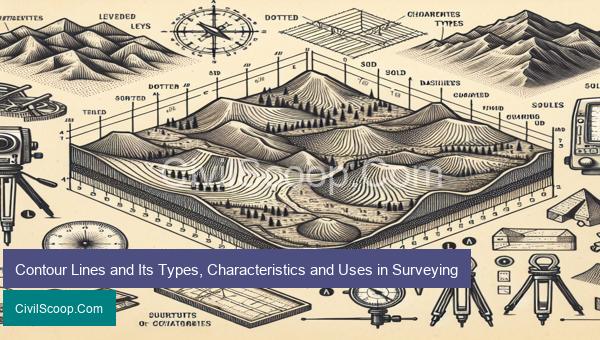
Contour lines, also known as isolines, are an essential tool in surveying and mapping. They represent the shape, elevation, and slope of the land by connecting points of equal value, such as elevation or temperature. There are various types of contour lines used in different fields, including topography, hydrology, and geology. With their distinctive characteristics and applications, they play a crucial role in providing accurate and detailed information about the land. In this article, we will delve into the world of contour lines, exploring their types, characteristics, and uses in surveying.
Table of Contents
Characteristics of Contour Lines in Surveying
Contour lines are an essential tool used in surveying to represent three-dimensional objects on a two-dimensional map or drawing. They are lines that connect points of equal elevation on the surface of the earth. These lines are used to create topographic maps, which are crucial in various civil engineering projects such as road construction, building construction, and land development. Understanding the characteristics of contour lines is crucial for accurate and efficient surveying. Below are some of the main characteristics of contour lines in surveying.
1. Elevation: Contour lines represent points on the ground that share the same elevation. This elevation is usually measured in feet or meters above sea level. The lines are drawn to connect points with the same elevation, creating a continuous line along the surface of the earth.
2. Equal intervals: The vertical distance between contour lines is known as the contour interval. The contour interval is usually constant on a specific map and is used to determine the steepness of the terrain. Dense contour lines indicate steep slopes, while widely spaced ones represent gentle slopes.
3. Closed loops: Contour lines never intersect each other unless they represent overhanging cliffs or caves. These lines form closed loops on a map, indicating areas of higher or lower elevation. V-shaped contours with the pointy end pointing downhill are called hachures and are used to represent a depression on the ground.
4. Contour direction: The direction in which contour lines are drawn provides information about the shape of the terrain. Contour lines that are closely spaced and curved indicate steep slopes or abrupt changes in elevation. On the other hand, widely spaced contour lines that are nearly straight represent flat or gentle slopes.
5. Contour density: The spacing of contour lines on a map is an indication of the terrain’s roughness. For example, a map with closely spaced contour lines indicates a steep and rough terrain, while widely spaced lines represent a relatively flat surface.
6. Index contours: Index contours are usually thicker and darker than the other contour lines on a map. They are labeled with the elevation they represent and are drawn every fifth contour line. Index contours help in determining the overall shape and orientation of the terrain.
7. Interpolation: Contour lines are drawn based on the elevation of known points, such as benchmark elevations. Points in between these known points are interpolated, and contour lines are drawn to connect them. This process requires specialized equipment and techniques to ensure accuracy.
8. Depiction of features: Contour lines can also represent various features on the landscape, such as rivers, streams, and cliffs. These features are highlighted by special symbols and can provide useful information for surveying and engineering purposes.
In conclusion, contour lines play a crucial role in surveying by providing a clear representation of the terrain’s elevation and shape. They are a vital tool for civil engineers in designing various structures and infrastructure, and understanding their characteristics is essential for accurate and efficient surveying.
Types of Contour Lines in Surveying and their Importance
Contour lines are an essential tool in surveying, used to represent the shape and elevation of the land on a two-dimensional map. They are formed by connecting points of equal elevation on the ground and are depicted as curved or straight lines that are closely spaced in areas with a steep slope and farther apart in flatter areas. Contour lines provide valuable information to engineers, architects, and planners in understanding the topography of a site and in designing structures and infrastructure that are safe, efficient, and economical.
Here are the four types of contour lines commonly used in surveying:
1. Index Contour Lines: These are thick contour lines, usually every fifth line, that are labelled with the elevation of the land above sea level. They provide a quick reference to the elevation of a particular area and are used to determine the height of a land feature on the map. Index contour lines are crucial in representing the vertical profile of the land, enabling engineers to identify potential sites for construction.
2. Intermediate Contour Lines: These are lines that fall between the index contour lines and are usually drawn with a thinner and lighter line weight. They indicate the elevation of points between the adjacent index contour lines and provide a more detailed representation of the land’s topography. Intermediate contour lines are essential for engineers in identifying potential hazards such as steep slopes or depressions that could impact the construction of a project.
3. Supplementary Contour Lines: These are lines that are drawn to represent elevations that do not fall on the index contour lines. They are represented by a dotted or dashed line and are used to further refine the topographical information of an area. Supplementary contour lines are particularly helpful in showing minor features such as small ridges, gullies, and depressions that may not be captured by the index or intermediate contour lines.
4. Depression/Hatch Contour Lines: These are contour lines that indicate a depression or valley on the map. Instead of being drawn as regular contour lines, they are usually represented by a series of closed loops with tick or hatch marks on the downhill side. Depression contour lines are crucial for engineers in identifying areas with poor drainage, which may require additional measures to ensure the stability of structures.
In surveying, contour lines serve several important purposes:
1. Designing infrastructure: Contour lines allow engineers to analyze the topography of a site and design structures such as roads, buildings, and bridges that are suitable for the terrain. For example, steep slopes may require additional reinforcement, while areas with depressions may need additional drainage systems.
2. Calculating volumes: By using contour lines, engineers can calculate the volume of earthwork required for a construction project. This information is crucial in estimating project costs, determining the most efficient and cost-effective construction methods, and ensuring the project stays within budget.
3. Identifying potential hazards: Contour lines are essential in identifying potential hazards such as steep slopes, depressions, or unstable areas that could affect the construction process. Engineers can take necessary precautions and design solutions to mitigate these hazards.
4. Planning utilities: Contour lines provide information on the topography of the land, which is essential in designing utility systems such as stormwater drainage, water supply, and sewer lines. These systems must be carefully planned to ensure they function properly and do not cause any damage to the environment.
In conclusion, contour lines are an indispensable tool in surveying, providing valuable information to engineers and designers. They serve many purposes, from accurately mapping the land
Conclusion
In conclusion, contour lines are an important tool in the field of surveying, allowing us to represent detailed terrain features in a simplified manner. They are created by connecting points of equal elevation on a map and can be classified into three types: index, intermediate, and supplementary. These lines have several distinct characteristics, including a consistent spacing, the representation of slope and aspect, and the indication of topography. Surveyors use contour lines to analyze landforms, plan and design construction projects, and determine the optimal route for road or rail construction. They are also used in various industries, such as agriculture, forestry, and environmental conservation. With the advancement of technology, contour lines can now be generated using remote sensing and Geographic Information Systems (GIS), making